Archive for September, 2009
10
Sep

Staithes

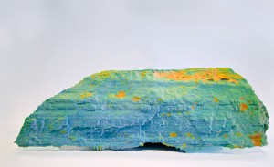
3D print of a section of the cliff at Staithes, North Yorkshire, colour coded to show erosion since 2003. Black areas are ‘holes’ in the scan data.
staithes_800

Data supplied by Dr. Nick Rosser and Dr. Michael Lim at the Dept. of Geography, Durham University.

Model was trimmed, healed and thickened using Rapidform XOS2.

08
Sep

Laser Scan

High resolution laser scan of a brooch found at a Roman Building known as Sladwick, north of Shapwick in Somerset. This model is massively decimated to produce about 5k polys. Click and drag in the window to view the model:

This model was produced by scanning using a Leica laser scanner – 7 scans in all, 4 on the top side, 3 on the reverse. The main issue in scanning this object was the fact that the pin moved between scanning one side and the other. This meant dividing up the point cloud data to separate the pin from the main body.
More »